Two Storms Worth Watching This Week
There's a particular kind of tension that builds before a week like this one. The air gets warm too fast. The sky does something restless. The forecasters start using words they don't reach for in February.
We're heading into one of those weeks.
Two separate storm systems are lined up to move through the central United States — one Wednesday, one Friday. Neither is a certainty, and neither is something to dismiss. What follows is a plain-language breakdown of what's coming, who should pay attention, and why this particular setup has the attention of people who spend their lives watching the atmosphere.
Wednesday: The Opening Act
The first system arrives Wednesday afternoon and evening, pushing out of Texas and Oklahoma and sweeping northeastward into Arkansas and southern Missouri. This one is the smaller of the two. Think of it as a fast-moving line of thunderstorms more interested in making noise and dropping hail than sticking around.
The primary concerns are large hail — the kind that dents cars and breaks windows — and gusty, damaging winds as the storm line passes through. There's also a low but real chance of a tornado or two, particularly ahead of the main line where individual cells can briefly organize before getting swept up into the broader system.
For most people, Wednesday looks like this: a stormy afternoon and evening, possible hail, winds picking up dramatically as the front passes, and then clearing by overnight. It's worth being aware of, but it's not the week's headline.
The headline is Friday.
Friday: The One to Watch
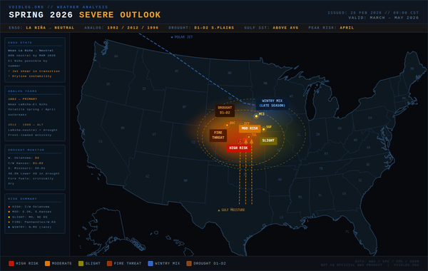
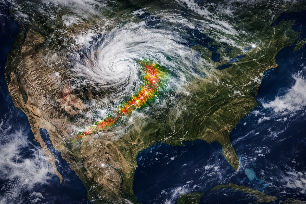
The second system is built differently. A strong upper-level disturbance — the kind that arrives with a powerful jet of wind high in the atmosphere — is forecast to push northeastward into the central Plains on Friday, dragging an unstable, moisture-laden airmass from Texas all the way up into the Missouri Valley.
What that means in plain terms: the atmosphere on Friday will be loaded. Warm, humid air near the ground. Fast winds aloft. A sharp contrast between the two. That combination is the recipe that severe thunderstorms need to become something more organized and more dangerous.
Forecasters are specifically highlighting the potential for supercell thunderstorms — the rotating, long-lived kind that can stay coherent for hours. These are the storms capable of producing all three major severe weather threats at once: large hail, damaging straight-line winds, and tornadoes. The Friday window appears to open in the afternoon and extend into the evening before the system eventually organizes into a larger line overnight.
A 15% probability area has already been drawn in the extended forecast maps by the Storm Prediction Center. That number sounds modest. At several days' lead time, it isn't — it represents meaningful confidence in an organized, dangerous event.
Why This Pattern Feels Familiar
Early March severe weather in the Missouri Valley and Southern Plains isn't novel. It happens with enough regularity to have its own character in the regional record books.
Last year, in March 2025, a nearly identical setup — strong upper-level system, loaded atmosphere, supercell window in the afternoon — produced an EF-3 tornado in southern Missouri and golf ball-sized hail across a wide swath of the region. The storms were fast, well-organized, and arrived with only a few hours of warning at the local level.
Go back to March 2006, and a nighttime outbreak across the Ozarks produced more than a dozen tornadoes, killed two people, and destroyed or damaged over 550 homes across the region.
One pattern worth noting from the historical data: tornadoes that form in early spring — particularly in March — tend to be stronger, not weaker, than their summer counterparts. When the atmosphere is still cool enough to produce sharp contrasts but warm enough to fuel instability, the results are often more violent. The records bear this out.
What You Should Actually Do
This isn't an article about panic. These storms may underperform. Forecasts this far out always carry uncertainty, and the atmosphere has a long history of being less cooperative than the models suggest.
But the setup is real, and it's worth a few simple steps before Friday:
Know where your shelter is. If a tornado warning is issued for your area, where are you going? A basement is ideal. Interior room on the lowest floor if not. Know this before you need it.
Have a way to get alerts that doesn't require you to be watching. A phone with weather alerts enabled works. A weather radio works better, especially overnight when storms can arrive while you're asleep. Wednesday's storms, in particular, are likely to peak after dark.
Watch the updates. The Storm Prediction Center issues updated outlooks each morning. By Thursday, the Friday picture will be considerably sharper. If the risk categories start climbing — from Marginal to Slight, Slight to Enhanced — take that escalation seriously.
The Week Ahead
There's a tendency to normalize severe weather in the middle of the country. It happens every spring. People in this part of the world grow up with it, learn to read the sky, learn which clouds to watch. That familiarity is useful. It shouldn't become complacency.
Two storms this week. The first arrives Wednesday evening and asks you to pay attention. The second arrives Friday and means it.
Keep watching the sky.
Data sourced from the NOAA Storm Prediction Center, NWS Springfield, and historical event records from the National Weather Service.