Weather Outlook Spring 2026
Looking at the Spring Ahead
Every spring season has a personality. You can read it in the bones of the atmosphere — the state of the Pacific, what the Gulf of Mexico has been doing all winter, how cracked and thirsty the ground is. Spring 2026 already has one: it's the personality of a season that's been wound tight all winter and is trying to figure out how to let go.
The pattern driving this spring begins, as it almost always does, with ENSO. We spent the winter in a weak La Niña. Not a monster, not a 2011-caliber event, but enough to tilt the dice — warm and dry through the southern Plains, storminess suppressed, moisture withheld. As of now, that La Niña is collapsing. The Climate Prediction Center puts a 90% probability on ENSO-neutral conditions through March–May 2026, with model consensus showing the Pacific warming toward neutral and even flirting with early El Niño by summer. The La Niña Advisory remains technically in effect, but the oceanic engine that powered it is running out of fuel.
That transition is the whole ballgame for spring 2026. It's also what makes this season complicated to read.
Finding the Analog
When you're trying to understand a season before it fully arrives, you look for years that wore the same fingerprints — same ENSO trajectory, same drought footprint, same time of year you're sitting in. For 2026, a few years stand out from the record.
1982 is perhaps the cleanest match. That year featured a weak La Niña or near-neutral winter that was already transitioning, with a rapid march toward a strong El Niño by summer. The spring of 1982 was the bridge season — and it was volatile. An April 2–3 outbreak produced 61 tornadoes across the Plains. The atmosphere didn't wait for the Pacific to settle down before getting to work.
2012 is another useful mirror. Coming off a weak La Niña winter, it entered spring in an ENSO-neutral state with significant drought across Oklahoma and Kansas. The season had a strange, front-loaded quality — very active early spring (the March 2012 outbreak), then a quieter May, then a brutal summer of heat and drought expansion. The dryline was explosive when it could get moisture, but the lack of sustained Gulf moisture transport kept the season from being historically catastrophic.
1996 fits a slightly different mold but deserves mention. A weak La Niña transitioning to neutral, with a warm Gulf, led to an April that was loaded with significant tornado days across the southern Plains and Ozarks. It's less remembered than 2011 or 2008, which is part of why it's useful as an analog — it shows that a transition-year season doesn't need a dramatic ENSO backing to produce dangerous weather.
The common thread across all three: the transition period from La Niña to neutral, particularly when a warm Gulf of Mexico is part of the setup, correlates with an elevated risk of organized, violent severe weather across Kansas and Oklahoma in April, with the risk corridor potentially shifting northward into Missouri by May. This is backed by NOAA Climate Program Office research showing that weak La Niñas transitioning toward neutral favor April tornado outbreaks throughout the South, particularly in Oklahoma and Kansas, as opposed to the Ohio Valley focus typical of stronger La Niña events.
If you had to name one year as the closest analog for 2026 and you had to put money on it, 1982 is the call — specifically that spring's front-loaded, volatile character during the ENSO transition, combined with a dry, fire-prone early season across the Plains.
The Physical Picture
The science behind why a La Niña-to-neutral transition is dangerous for this region comes down to two competing atmospheric forces that briefly coexist in a really uncomfortable way.
During La Niña, the polar jet stream tends to ride farther north across the western U.S. and then dig south into the central Plains. That pattern keeps severe weather relatively suppressed over the traditional Plains states and pushes activity toward the Southeast and Dixie Alley. But as La Niña collapses, something called "atmospheric hysteresis" kicks in — the atmosphere lags behind the ocean. The ocean can reach neutral, but the circulation patterns established over winter don't instantly reconfigure. For weeks, sometimes a couple of months, you get a hybrid state: the lingering momentum of La Niña's upper-level flow, but the subtropical jet — energized by that warm water transitioning in the Pacific — begins spinning up simultaneously.
When both jets are loaded at the same time, you get deep-layer shear values that meteorologists describe, carefully, as "impressive." You also get a dryline that, when Gulf moisture finally pushes north, can act like a hair trigger. The contrast between the drought-baked surface of western Oklahoma and central Kansas against the first real moisture surges of the season creates an instability gradient that doesn't need much of a synoptic push to go absolutely ballistic.
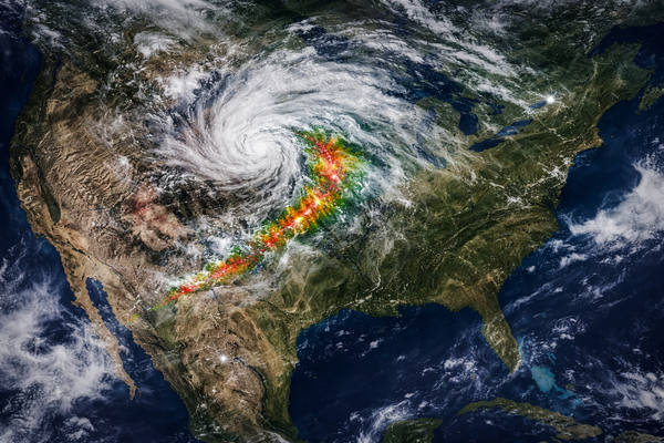
Add to this: the Gulf of Mexico has been running above-average in sea surface temperature this winter. A warmer Gulf means higher evaporation rates, and when southerly flow eventually establishes itself, it transports that moisture northward more aggressively. That's the gasoline. The jet stream shear is the match. The dryline, especially with parched soils across western Oklahoma and southern Kansas baking under this week's 75–78°F warmth, is where they meet.
The Drought Factor
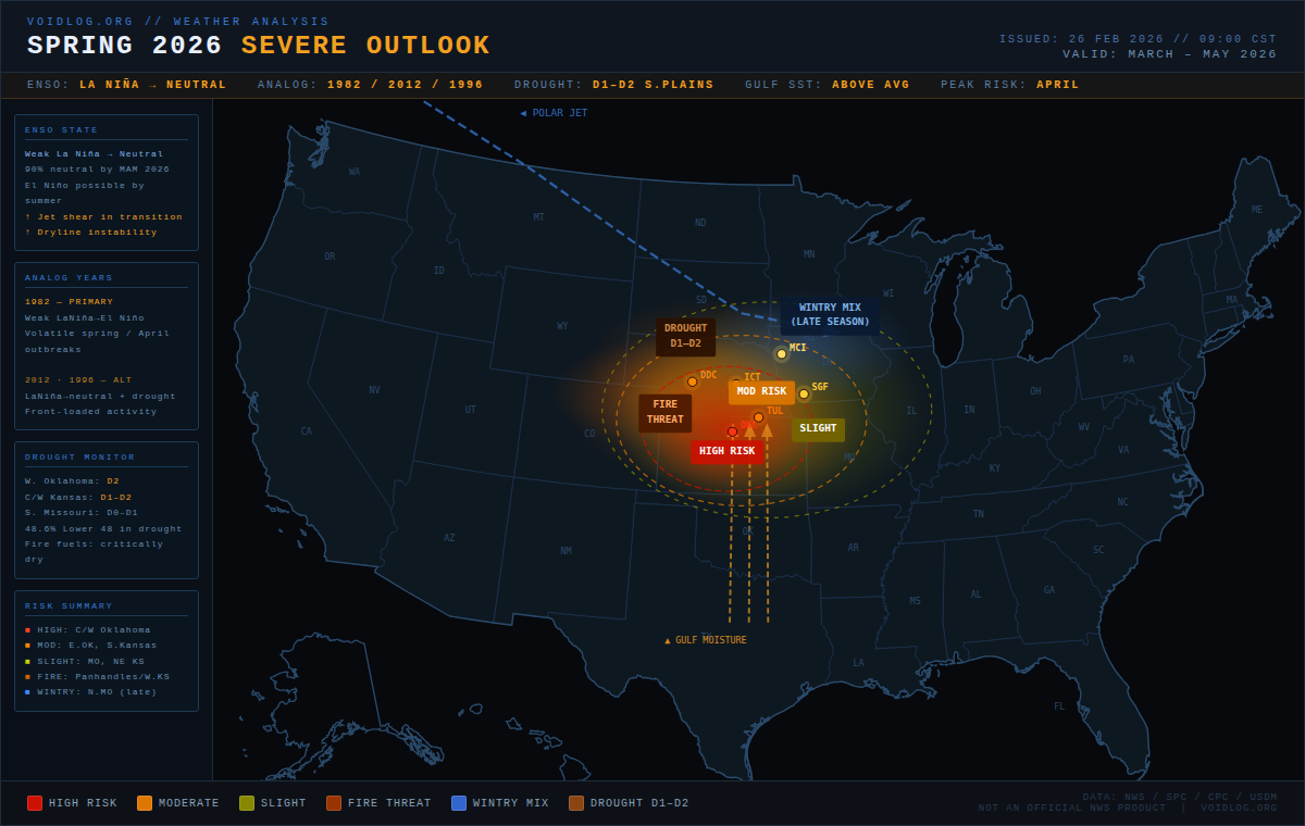
As of mid-February 2026, nearly 49% of the contiguous U.S. is in drought Drought.gov, and our region is well represented in that map. Western Oklahoma is in the grip of significant moisture deficits, with extreme drought conditions flagged in some areas. Southern Missouri has seen some improvement from recent precipitation, but the underlying long-term deficits remain. Central and western Kansas range from abnormally dry to moderate drought, with the western high plains considerably worse.
This matters for severe weather in a counterintuitive way. Drought doesn't prevent tornadoes — in some ways, it helps create them. Parched soils heat faster, amplifying low-level temperature gradients and boosting CAPE (Convective Available Potential Energy) on storm days. The dryline, which separates dry continental air from moist Gulf air, anchors more aggressively over drought-affected terrain. When a storm system finally does drag a plume of Gulf moisture north across that boundary, the contrast is sharper, and the storms that form on it are meaner.
NWS Wichita forecasters have already flagged this explicitly, noting that the La Niña to neutral transition "historically shifts towards more storms" and that "these patterns typically result in an increase of severe weather in Kansas, including tornado outbreaks in April." The Fence Post That's not speculation — that's their read on the analog record, and it matches the climatological literature.
Month-by-Month Risk Assessment
March — Fire Season First, Storms Later
March is the most nuanced month of this outlook. The transition hasn't fully played out yet. The big risk early in the month remains what we're already dealing with right now: fire weather. With vegetation across Oklahoma and Kansas in critically dry condition and southwest winds likely to stay active through at least mid-March, the fire weather threat is real and ongoing. Thunderstorm coverage will expand, but moisture return will be inconsistent — March storms tend to be more of the high-shear, low-CAPE variety, capable of producing damaging wind and large hail, with tornado risk present but not the primary hazard.
Don't sleep on it entirely, though. The early season is starting earlier than the climatological average, and the 2012 analog included a significant March outbreak in the Ozarks. Missouri and southeast Kansas deserve attention even in March.
April — The Month to Watch
This is the crux. If the analog years mean anything, and they do in a probabilistic sense, April 2026 is the highest-risk window for significant tornado outbreaks across our region. The dryline becomes active in earnest across Oklahoma's western counties. Gulf moisture starts making consistent northward pushes. The jet stream, still carrying some of that La Niña-transitioning energy, drops into the southern Plains repeatedly. The ingredients for supercell thunderstorms — wind shear, instability, a trigger — can all phase together on the same day.
The research is pointed here. When a two-year La Niña transitions to an El Niño or neutral, the probability of outbreaks in Kansas and Oklahoma rises substantially compared to the climatological average. The geographic focus is roughly from the dryline in western Oklahoma and Kansas eastward — which means communities along the I-44 and Kansas Turnpike corridors are squarely in the target zone. Missouri's Ozarks and the Springfield metro region should also be watching April carefully, as storm tracks that initiate in Oklahoma frequently mature and become tornado-capable by the time they reach the Ozark Plateau.
May — Pattern Shift, Broader Target
By May, the ENSO transition will likely be complete or very nearly so. Neutral conditions mean the jet lifts northward, the storm track migrates with it, and the primary severe weather focus shifts toward the central and northern Plains. However, this can also be when some of the season's most photogenic and destructive events occur across southern Kansas and the Missouri River Valley. May tends to be when moisture values reach their seasonal peak, and even with a shifting jet, any residual troughing that digs into the Plains can produce explosive convective development.
The CPC seasonal outlook for MAM 2026 supports above-normal temperatures for the southern tier of our region and near-to-below-normal precipitation for much of the southern Plains. That's not a recipe for a quiet May — it's a recipe for volatile events when the atmosphere finally destabilizes.
The Bottom Line
Spring 2026 for the Oklahoma–Kansas–Missouri corridor is not a year to underestimate. The ENSO transition state, the drought footprint, the warm Gulf, and the analog record all point toward a season with real potential for significant, organized severe weather events — the kind that produce long-track tornadoes and widespread damage. The analog years of 1982, 2012, and 1996 all share the same transitional fingerprint, and none of them were quiet.
That said, ENSO is not a forecast. It's a context. It weights the dice. A transitional year doesn't guarantee a catastrophic season, and some La Niña transition springs have come and gone without a major event. What it does mean is that when the synoptic setup comes together — and it will, at least a few times between March and May — the environment will likely be primed to produce severe weather at the higher end of what's possible.
Watch April. Watch the dryline. Keep the weather radio charged.
Sources: NWS CPC Seasonal Outlook, WMO Global Seasonal Climate Update MAM 2026, U.S. Drought Monitor (Feb. 17, 2026), NOAA Climate.gov ENSO/Tornado research, NOAA Climate Program Office tornado outbreak research, NWS Wichita/Tulsa/Springfield forecast discussions, IRI ENSO probability forecast (Feb. 2026), CRV Science 2026 Tornado Season Assessment.